 |
| A steadily rising track follows Hayeswater Gill to Hayeswater itself before heading north-east up to The Knott from where we headed south. |
 |
| The track from The Knott leads to High Street at 828m, but we branched off east over Kidsty Pike and down to the shores of Haweswater. |
 |
| As we passed over Kidsty Pike we got our first view of our canping spot for the night down towards the bottom of The Rigg, the long ridge running right to left in the picture. |
 |
| A closer view of a very quiet shoreline where we only saw two other tents over towards the tree line. |
 | |
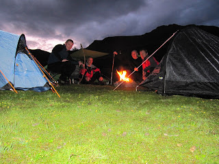
| With the tents all up it was time to get some food and get the fire going. |
 |
| Don't worry, the firewood was brought by us! 99 pence for a self lighting long that lasts up to two hours! |
 |
| Early morning sun from the doorway of my tent. |
 |
| Peace and quiet. |
 |
| Cup of tea followed by porridge (mashed up flapjacks in milk) and bananas. |
 |
| Some of the remaining dry stone walls that were part of the village of Mardale before it was flooded to create Haweswater Reservoir. |
 |
| After a leisurely breakfast we packed our gear and set off up The Rigg towards High Street. As we gained height we got better views down Hawwswater. |
 |
| The Rigg itself rises up from the waters edge and gains roughly 600+ metres of height. |
 |
| Halfway along The Rigg looking back down to Haweswater. |
 |
| Small Water, just visible to the left of The Rigg, sitting below Harter Fell and Mardale III Bell. |
 |
| Blea Water is also passed en-route. Only one small tent was spotted on the shoreline. |
 |
| I had read there were possibly some grade 1 or 2 scrambles on Raven Crag in Threshwaite Cove, but was surprised to see what looked like people rock climbing on the crag as we passed. |


