Information and photos of my mountaineering trips in Scotland,England and Wales:
Including hillwalking,scrambling and easy rock climbing.Also via ferrata, skiing and alpine trips in Europe.

Like this blog!

Wednesday, 11 August 2010

Swiss Alps - Allalinhorn 4027m via The Hohlaubgrat, 11th August, Day 2.


And so after not the best of sleep listening to the hippo two beds away from me, came the dreaded knock at the door at 4am. Rather annoyingly the hippo or his pals on the top bunks didn't bother to get up, and were still in bed by the time we'd had our breakfast and left! Anyway we were out of the hut by a leisurely 5am, giving me time to confirm the way we were going in the dark, after a quick a quick recce the day before, and to casually spy on other folks to check the way. From the hut we descend a loose and rocky path down onto the boulders at the edge of the Hohluab Glacier. In daylight this would be easy, but in the dark with a bit of a drop to the left it took a little more care.
Although I knew the general direction, I wasn't sure of the actual route across the galcier so I kept the team in front in my sights whilst we stopped to put crampons on.


It was still pretty dark as we made our way across the glacier, but thankfully there weren't any major crevasses and what there were, were easily crossed.


The way ahead looked a bit ominous in the dark but I knew we had to bear left-ish at some point to gain the start of the Hohluabgrat ridge which would lead us all the way to the summit of the Allalinhorn.


Lorna trying not to look tired as we stop for a wee break. A team of four can be seen ahead on the snow slope, centre of the picture.

Me, also just starting to wake up. Despite the dark and gloomy start, and being on top of a sheet of ice, it wasn't all that cold and pretty soon the sun would be up.

Soon we were off the ice and onto the snow slope, zig-zagging our way leftwards towards the central rock band that forms the Hohlaubgrat. 

We were getting level with the Mittel-Allalin, the worlds highest revolving resteraunt (apparently) as the piste bashers for the Saas Fee ski area set off to work.

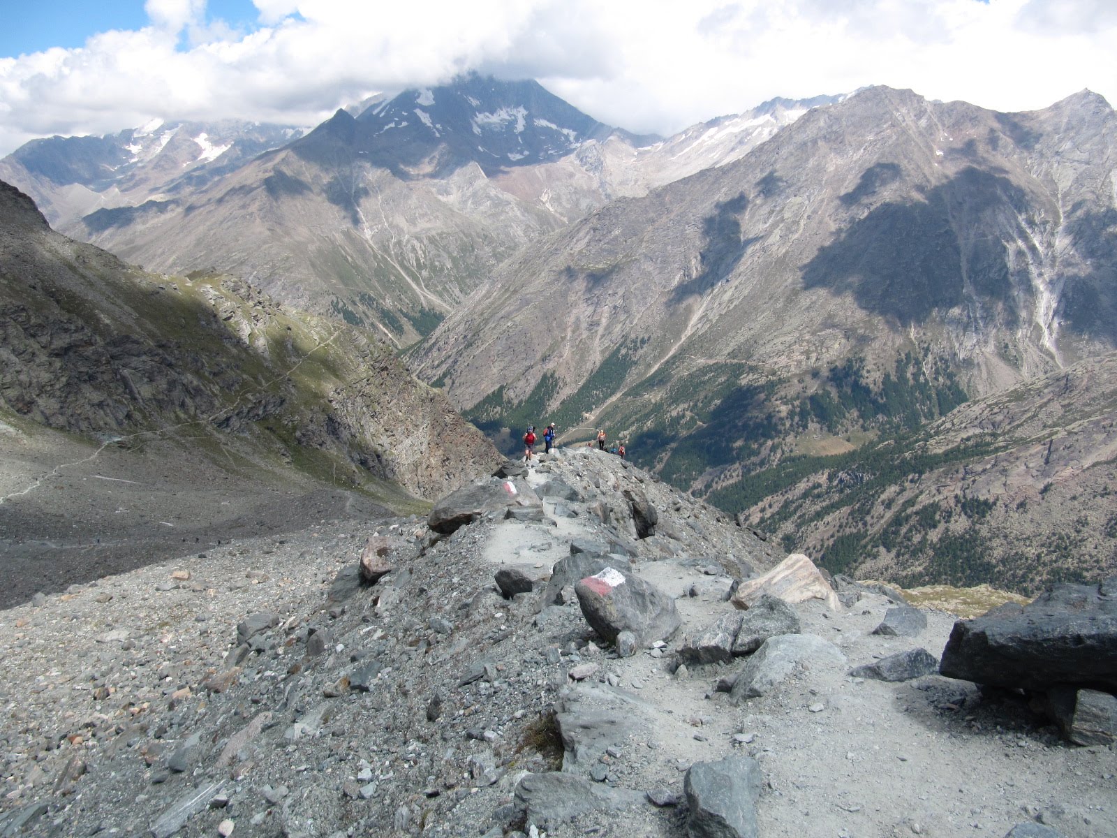
Looking back over our route over the Hohlaub Glacier as the sun rises over the Swiss Alps.


Gradually the slope gets a little steeper as you get higher up the ridge.


The Lagginhorn and Weissmies above the clouds in the distance.

More teams arriving having left from the middle station of the Metro underground railway that goes up to the Mittel-Allalin.

High above the Mittel-Allalin. The middle station has a tunnel that leads out onto the glacier somewhere central at the bottom of the rock ridge, about centre of the picture.  

Lorna leading for a while as the summit of the Allalinhorn comes into view.

The final easy snow crest that leads up to the 30m rock band.

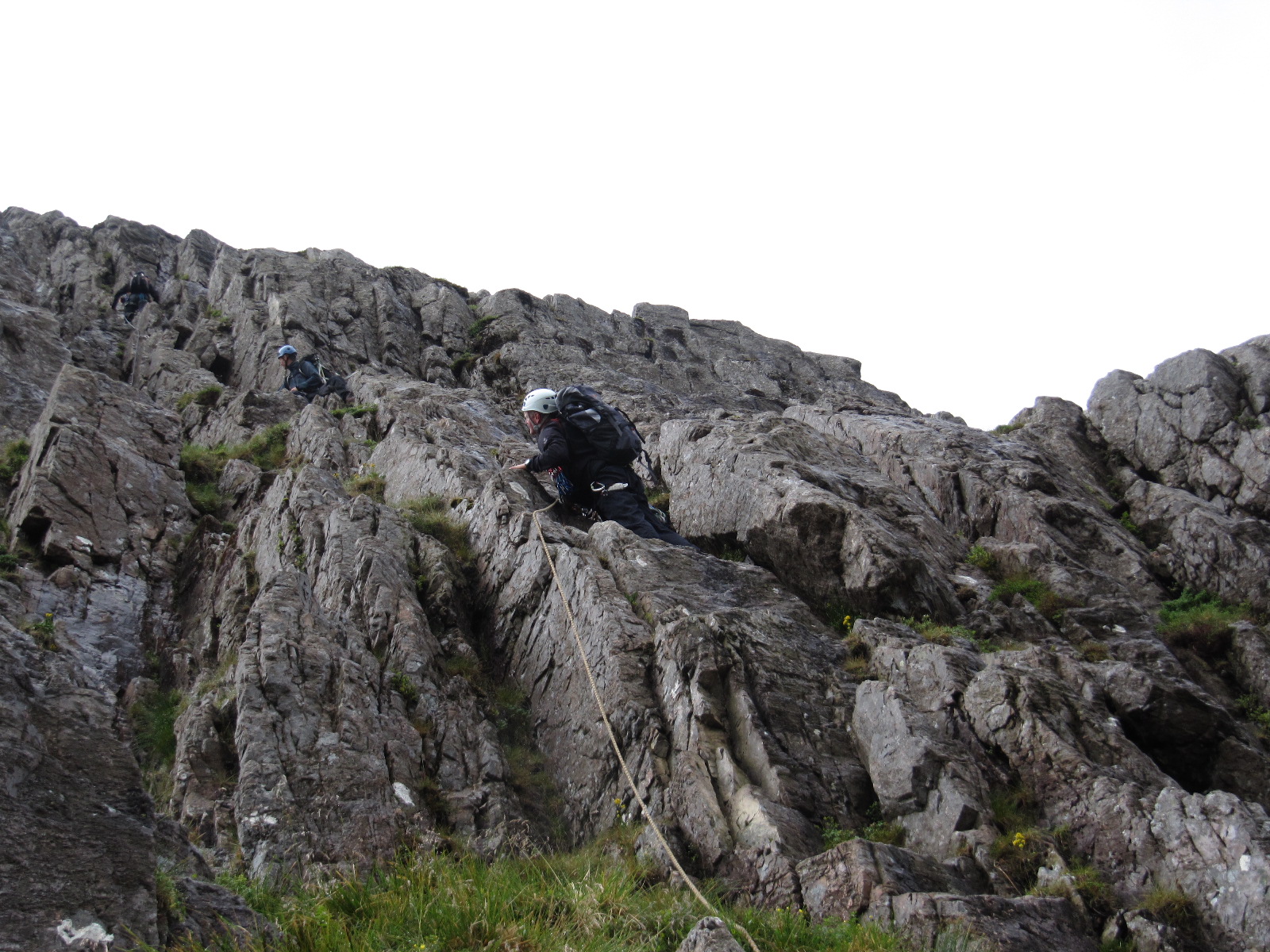
This is where the fun, if you can call it fun really started! This part is a 30m section of about V-Diff, however there was a queue of people waiting to get up it. At one point a Swiss guide led his clients up through what we thought were people still climbing up the route. It turned out that they were attempting to come down the way most folks were going up and causing chaos. We must have waited at least 45 minutes or longer as body after body (about 8-10 in all) came down by various methods and different ropes, making going up far to dodgy. At one point we moved from our uncomfortable and exposed stance to make ourselves safe around a spike, only to have one of these jokers knock Lorna's axe from it's snow placement and send it on it's way down to Saas Fee. Luckily I caught it, but the offending abseiler arrogantly said it wasn't his problem as it wasn't his axe - nice! Then another female landed in the exact spot where Lorna was standing only minutes earlier, and slid several feet before her crampons stopped her. Had Lorna been there she would've been sent for a bit of a slide! Eventually they buggered off and left us in peace to climb up.
(I think they were Italian though I'm not sure?).


Lorna finally getting peace to climb the bolted 30m pitch which also has bits of tat for aid if you find it a little sketchy in crampons, but otherwise it's not too bad.

Looking down to the Mittel-Allalin and Saas Fee.

Lorna finally triumphant at thesummit cross on the Allalinhorn.

Me and my helmet at it's annoying jaunty angle!

From the summit we took the "normal" route down to the Mittel-Allalin for a well deserved beer and a free trip down on the underground Metro (I don't know how it happened, but we never got to pay?) then the cable back to Saas Fee.


Tuesday, 10 August 2010

Swiss Alps - Allalinhorn 4027m, 10th August 2010, Day 1.

After two days of "warming up", we decided to go for the Allalinhorn via the Hohlaubgrat Route from the Brittania Hut. However with time to kill, we had a couple of shots on the Feeblitz bobsleigh run in Saas Fee first. We then took the Plattjen lift once again to 2500m and then the path that passes below the Mittaghorn and continues on to the Brittania Hut at 3030m which sits above the Chessjen Glacier. And with more time to kill we stopped for a drink at the resteraunt by the lift. This route takes about two hours although there is a shorter approach from the Felskin lift but that seems like cheating!


On the way we passed below the Mittaghorn and the ridge leading round to the Eginner at 3370m.


As we made our round we go our first veiw of the Brittania Hut overlooking the Chessjen Glacier.


We also made a few friends on the way - maybe we would see them again in a stew later at the hut?


They obvioulsy weren't too bothered by people as they just barged their way through on the path - very alpine like manners!


Looking back down the moraine slopes to our route just before crossing the glacier.


It was interesting to see so many day walkers slipping and sliding around on the glacier seemingly unaware of the possible dangers atlhough on a day like today, it all seems benign. Crampons weren't neccessary but there were still a few holes to fall down especially at the edges, just where all the day walkers were trying to "ski" down in their boots!


One of the safe crossings over the soft edges of the glacier.


Almost at the hut now with the glacier below, the Eginner in the background and the route from the Felskin lift through the middle of the picture.


At last after a seemingly long two hours in the afternoon heat, we arrived at our "hotel" for the night at about 3pm ish - The Brittania Hut sitting at 3030m.


We had aleady booked the day before by phone and although most of the staff speak good english, and me a little german, they still had the wrong name down in their book. However we still got a bed for the night although sleep was at a premium as we had the loudest snorer in Switzerland in our room! I did take ear plugs and my headphones for some music but I was just too lazy to get them out. Still the food was excellent and we had a good conversation with two lads from Belgium: Wim and Dennis who managed to eat any left over food they could find! They were heading for the Rimpfischorn with a 3am wake up call, and so retired even earlier than us who had a 4am call for the Allalinhorn.


From the hut looking out over to the Stralhorn (i think?) at 4190m. So after a couple of beers a good meal it was heads down at about 8pm and attempt to get some sleep. It wasn't long before there was a knock at the door inviting us for breakfast... 

Monday, 9 August 2010

Swiss Alps - Jegihorn VF, 9th August 2010.

Monday morning and we were more organised and hired our VF kits (10chf , about £6ish) and took the Hohsaas gondola up to the middle station, Kruezboden at 2400m. From there a stiff walk took us to the start of the Jegihorn Via Feratta. There are also a number of climbing routes on the Jegihorn which we noticed several teams on.


The Jegihorn itself is the peak on the left at 3206m, but the VF route goes up the face of the right hand peak, then takes you across a wire bridge from right to left which is just visible spanning the two peaks.


The route winds it's way up with constant views across to the snow capped Weissmies.


A closer view of the Weissmies with several teams making their way down.


The start of the route takes a line up the chimney feature to the left pf the picture which if you look closely has a couple of people already in it.


The route then bears left so get to see the wire bridge a little closer - no way back now!


Once you've taken your first closer look at the bridge, the cable winds back to the right, up ladders and over exposed slabs. The Weissmies Hut can be seen way below.


As you reach the summit of the right most peak you get to look down on the rest of the route as people shuffle their way across the huge drop below.


You can also see the cargo net which you also have to climb, facing out only to reach even steeper and more exposed rock!


As the cable takes you down to the bridge the true size of it all becomes  very real!


I was hoping to do the easier route to the right which 
 avoids the bridge (two people in red and blue are near the top of it in the picture) but after seeing a 10/11 year old Swiss boy do it I guess I had no choice!


After the andrenaline filled crossing comes the strength sapping cargo net but at least you get to look all the way down to the rocks below!


And then after the cargo net comes the exposed ledges and cracks before the route eases off at the summit. Im some places, extra holds had been made by bolting peices of rock to the face of the mountain -some of which were a bit loose!


Jegihorn Summit video.


However the struggle was worth it and the crack with other teams crossing the bridge was priceless. Pant filling jokes seem to cross all languages! We also got great views of the entire Saas valley.
The photo above shows the Weissmies with the Trift Glacier below and the centre section of seracs and crevasses you have to cross.


 Saas Fee at 1800m overlooked by over half a dozen 4000m + peaks.
Click here for Saas Fee map.


Taschorn 4491m, Dom 4545m (Highest Swiss peak solely on Swiss soil) and Lenzspitze 4294m.


And then it was a 2 hour dash to catch the last lift down from Kreuzboden!

Sunday, 8 August 2010

Swiss Alps - Mittaghorn, Saas Fee - 8th August 2020.

We had planned to do the Via Feratta on the Mittaghorn 3143m, but we didn't know that all the gear hire shops would be shut on the sunday! So without any VF kit we decided to still take the normal, steep walkers path to the Mittaghorn summit. After a short walk from the top of the Plattjen chairlift it's straight into the grind of alpine uphill walking, but it's all good acclimatisation for the higher peaks to come later in the week!


Looking up at the massive rock lump of the Mittaghorn.


Looking down from the path up to the summit.


Lorna taking a break on the way up. The Mattmark Barrage can be seen in the distance.


Ibex also taking a break on the slopes of the Mittaghorn.


Myself and Lorna on the slightly chilly but clear summit of the Mittaghorn.


Looking along the ridge from the Mittaghorn to the Eginner.


Video from the suimmit.


Our first closer view of the Allalinhorn which we planned to do in a couple of days.


From left to right;
The Eginner (snow-less) 3370m, Allalinhorn 4027m, Feekopf 388m and Alphubel 4206m in the clouds.


And on the other side of the valley, the Saas Allmagell side you can see the Dri Hornli Ridge with the Allmageller Hut just visible to the right. The hut would be our stop over if we choose to do travers over the Weissmies and down to Hohsaas above Saas Grund.


On the descent, we also saw the Brittania Hut at 3030m which would be our accommodation if we did the Hohlaubgrat route to the summit of the Allalinhorn at some point during the week.
We got back to the Plattjen lift and went down to Saas Fee and found we had still had time on our hands, so we had a go at the high wire course with it's various obstacles and zip wires, ending with two crossings high above the Fee Gorge. Sadly on the same day, someone died whilst attempting the Via Feratta and zip line route lower down in the gorge unguided.


Lorna on one of the rope course obstacles.


Video of my first crossing of the gorge.


And here she is again taking the return zip wire back across the Fee Gorge.


And finally back across the gorge and the end of the course, which turned out to be hard work in the end!  

Sunday, 1 August 2010

North Buttress, Buchaille etive Mor - 1st August 2010.

With a bit of vague forecast of watery sunshine, my self, Gordon and Willy headed for Glencoe. We had planned to do the North Buttress route on Bucahaille etive Mor, and on the easy scramble up past the two large blocks that act as a guide to finding the route, we were certain that we would get more water than sunshine.
However, we were surprised to see the cloud base lift and apart from the occasional spot of brief dampness, we did the whole route with just one layer.
The route itself is Grade III/Mod, but in the damp slightly greasy conditions it may be Diff? Basically you follow a series of cracks and chimneys for most of the route, and it's open to variation although one higher section of chimney is a wee bit tricky especially when wet or greasy and can be bypassed to the right before heading back left.
We roped up, although perfectly do-able without it, it offered some reassurance on the wet bits and as usual is a good route to practice leading, belaying etc.

       
Willy and Gordon applying some light sunscreen!


Gordon (leading) and Willy scrambling on the easy lower section of the route with the higher steeper section just visible above.


Gordon having a shot at leading on the lower part of the main buttress which gets progressively steeper but always with lots of protection and holds. There was a team in front, also practicing stuff which gave us time to enjoy the views and practice ours!

 
 Gordon higher up in the chimney system now with some entertaining fallen blocks to negotiate.

 
Willy, taking second place on the rope.

 
Me as last man, looking down the section with the fallen blocks (just below and left of the small pinnacle). It is possible to go up left of the pinnacle (right in the photo), but it was very wet and greasy.
 

The route eases off after a while and easier scrambling and walking leads you direct to the summit shelter with views of Crowberry Gully and Crowberry Tower to your left. The photo above is looking down to the car park, with the Devils Staircase section of the West Highland Way leading up and over to Kinlochleven, and Blackwater reservoir visible high on the right.  

Sunday, 11 July 2010

Wet weather programme - Wasdale Head, 10th - 11th July 2010.

It was a case of damage limitation as myself and the Gunner set off from Seathwaite in the pouring rain. We were hoping the rain might stop later in the day, but we changed our plan of going up to Styhead Tarn and over Great Gable to going up Ruddy Gill from Stockley Bridge, detour past Sprinking Tarn, over to the stretcher box below Gable and straight down to Wasdale.
Even then we still got soaked and it was a relief when the rain finally eased so we could get the tents up.
Then it stareted raining again!
The tents; Coleman Epsilon 2 and Easycamp Star 100, both coped well with the almost constant rain. Unfortuneatly when you have such small tents, gettingwet kit dry isn't easy.


Luckily the Wasdale Head Inn is right next door to the campsite (not the National Trust site which is about 1km away), so we managed to get some gear dry as we sat and ate our meals in the bar. The food is simple but filling and served extremely quickly. The beer is nice too!
The following morning, the rain finally stopped about 10am and we were relatively dry aswell, so we set off for Brown Tongue and Hollow Stones. It was still quite windy though as we climbed the little path/chimney at the head of Hollow Stones which brings you out at Mickledore, before reaching Scafell Pike at 977m. The sun almost came out as we stopped for the last of our rations, before descending to the col between the Pike and Broad Crag, and then the path down to the Corridor Route and back to Seathwaite via Styhead Tarn.  

Lessons learnt; 
Take spare socks -  I hadn't planned on getting so wet
Wear gaiters - I hadn't planned on getting so wet
Take more plastic bags - I hadn't planned on getting so wet
Invest in a dry bag liner - yeah you guessed it
The slightest forecast of rain - Don't go out with a small, one man tent!